All NewsEducationTV
Equities & FundsCrypto & Digital AssetsAI & TechnologyBusiness & CorporateUS Politics & PolicyGeopolitics & Global RiskMacro, Rates & FXCommodities & EnergyEuropean Politics & MarketsAsia-PacificReal Estate & Property
All NewsHome
← Back to Geopolitics & Global Risk

Risk of lake burst near China-Nepal border disaster site wanes

Created at 29 Aug · 6:12 AM1 source↑ Market-relevant
IN SHORT

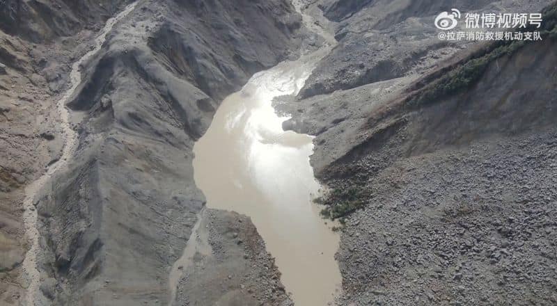
Chinese authorities stated on Saturday that the risk of a glacial lake bursting near the China-Nepal border has decreased, as satellite imagery indicates the lake's size has shrunk and water is flowing through it. The lake formed after a devastating flood earlier this week.

Key Numbers

99,000 sqmlake surface area on Saturday morning
21,000 sqmlake size reduction since Thursday
14football fields combined size of the lake
120,000 square metersestimated area of a second, larger body of water
7China's death count from the disaster
554people still missing
500villagers and construction workers evacuated
555tourists evacuated

Who's Involved

Chinese authorities
stated the risk of a lake burst has decreased
Water Resources Ministry
cited by CCTV regarding lake size and flow
China Anneng
state-owned enterprise monitoring the lake
Chen Hongqi
senior engineer at Ministry of Natural Resources' Geological Disaster Technical Guidance Center
Nepal's Disaster Management Authority
official stating flood risks remain until lakes drain
Risk of lake burst near China-Nepal border disaster site wanes

↳ Why This Matters

The receding water levels in the glacial lake reduce the immediate threat of further catastrophic flooding downstream, potentially allowing rescue and recovery efforts to proceed more safely in the disaster zone.

Key facts

  • The risk of a glacial lake bursting near the China-Nepal border has decreased, according to Chinese authorities.
  • Satellite imagery indicates the lake's size has shrunk and water is flowing through it.
  • The lake formed after a devastating flood earlier this week caused by a glacier collapse.
  • The lake's surface area was 99,000 sqm on Saturday morning, down from Thursday.
  • Rescue operations were temporarily halted on Friday due to an overflow from the lake.

The threat of a glacial lake bursting near the China-Nepal border, formed after a devastating flood earlier this week, has diminished, Chinese authorities announced Saturday. Satellite images from Thursday to Saturday morning indicate the lake's size has shrunk, with water slowly flowing through it and decreasing the reservoir.

The lake, straddling the border at the confluence of two rivers, had a surface area of 99,000 square meters on Saturday morning, a reduction of 21,000 square meters since Thursday, according to state broadcaster CCTV citing the Water Resources Ministry. This area is equivalent to about 14 football fields.

The flood, caused by a glacier collapse on Wednesday, sent a torrent of rock, ice, and debris through Himalayan river systems, destroying a border port complex and resulting in hundreds of deaths and thousands missing. Experts had warned of high risks of secondary disasters, including from the newly formed lake, which could endanger downstream rescue operations.

China Anneng, a state-owned engineering firm monitoring the lake, dispatched a team with drones and surveillance cameras to gather more data. An overflow from the lake on Friday had temporarily halted rescue work before risks were deemed manageable. Authorities are also monitoring a second, larger body of water at the glacier collapse site, whose depth is currently unknown.

Despite the reduced risk, flood risks will persist until both lakes are fully drained, an official from Nepal's Disaster Management Authority noted. Rescue efforts continue in the challenging conditions, with China's death toll rising to seven and 554 people still missing.

Frequently asked questions

A glacier collapse on Wednesday sent a torrent of rock, ice, mud, and debris through the river systems, causing a devastating flood and forming the lake.

Satellite imagery shows the lake's size has shrunk, and water is flowing through it, decreasing the reservoir. Its surface area was 99,000 sqm on Saturday morning.

China's death count has risen to seven, with 554 people still missing following the disaster.

Yes, authorities are also flagging another larger body of water at the bottom of the glacier collapse, though its depth is currently unknown.

What Happens Next

01Flood risks will remain until the two lakes have fully drained.

How It Developed

A glacier collapse on Wednesday caused a devastating flood, sweeping away a border port complex and killing hundreds.
A lake formed by glacier debris posed a high risk of secondary disasters.
Satellite images from Thursday to Saturday morning showed the lake's surface area decreased by 21,000 sqm.
Chinese authorities stated on Saturday that the risk of the lake bursting has decreased.
Rescue operations were temporarily halted on Friday due to an overflow from the lake.
Authorities are monitoring another larger body of water at the bottom of the glacier collapse.
Flood risks will remain until the two lakes have fully drained.

Sources

T1
Risk of lake burst near China-Nepal border disaster site wanesReuters

Related Stories

China's satellites capture Nepal flood site images
28 Aug · 12:06 PM
Rescuers find 2 survivors near Tibet border after China-Nepal floods
29 Aug · 4:50 AM
France reports four nationals missing after Nepal flash flood
28 Aug · 10:07 AM
Deadly Nepal-China flood highlights region's danger and trekking allure
28 Aug · 5:46 PM
China's information controls hamper Tibet flood damage assessment
28 Aug · 2:21 PM