All NewsEducationTV
Equities & FundsCrypto & Digital AssetsAI & TechnologyBusiness & CorporateUS Politics & PolicyGeopolitics & Global RiskMacro, Rates & FXCommodities & EnergyEuropean Politics & MarketsAsia-PacificReal Estate & Property
Story archiveAll categories
← All Stories

Europe's Copernicus Browser adds wildfire tracking layer

Created at 7 Aug · 9:51 PM1 source↑ Market-relevant
IN SHORT

Europe's Copernicus Browser, a free satellite imagery service, has added a new wildfire visualization layer. This enhancement, based on a remote sensing expert's script, allows for easier tracking of active fires, burning vegetation, and burned landscapes using high-resolution Sentinel-2 satellite data.

✉Newsletter

PiQ Daily

Pick your topics. Get only what matters, on your cadence.

Key Numbers

10 metersSentinel-2 imagery resolution
10 default visualization layersCopernicus Browser previously offered
August 4Wildfire visualization layer went live
250 metersNASA FIRMS tool resolution

Who's Involved

Copernicus Browser
Europe's free satellite imagery service
European Space Agency
Operates the Sentinel satellites for the EU's Earth observation program
Pierre Markuse
Remote sensing expert who wrote the wildfire visualization script
Simon Proud
Mission scientist for Sentinel-2 at the European Space Agency
Bellingcat
Investigative journalism group
NASA
Provides the FIRMS tool for fire detection
Europe's Copernicus Browser adds wildfire tracking layer

↳ Why This Matters

This development provides a more accessible and detailed free tool for anyone to monitor wildfires, aiding in public awareness and potentially informing response efforts during a time of increasing global fire activity.

Key facts

  • Europe's Copernicus Browser now offers a dedicated wildfire visualization layer.
  • The layer uses Sentinel-2 satellite imagery with 10-meter resolution.
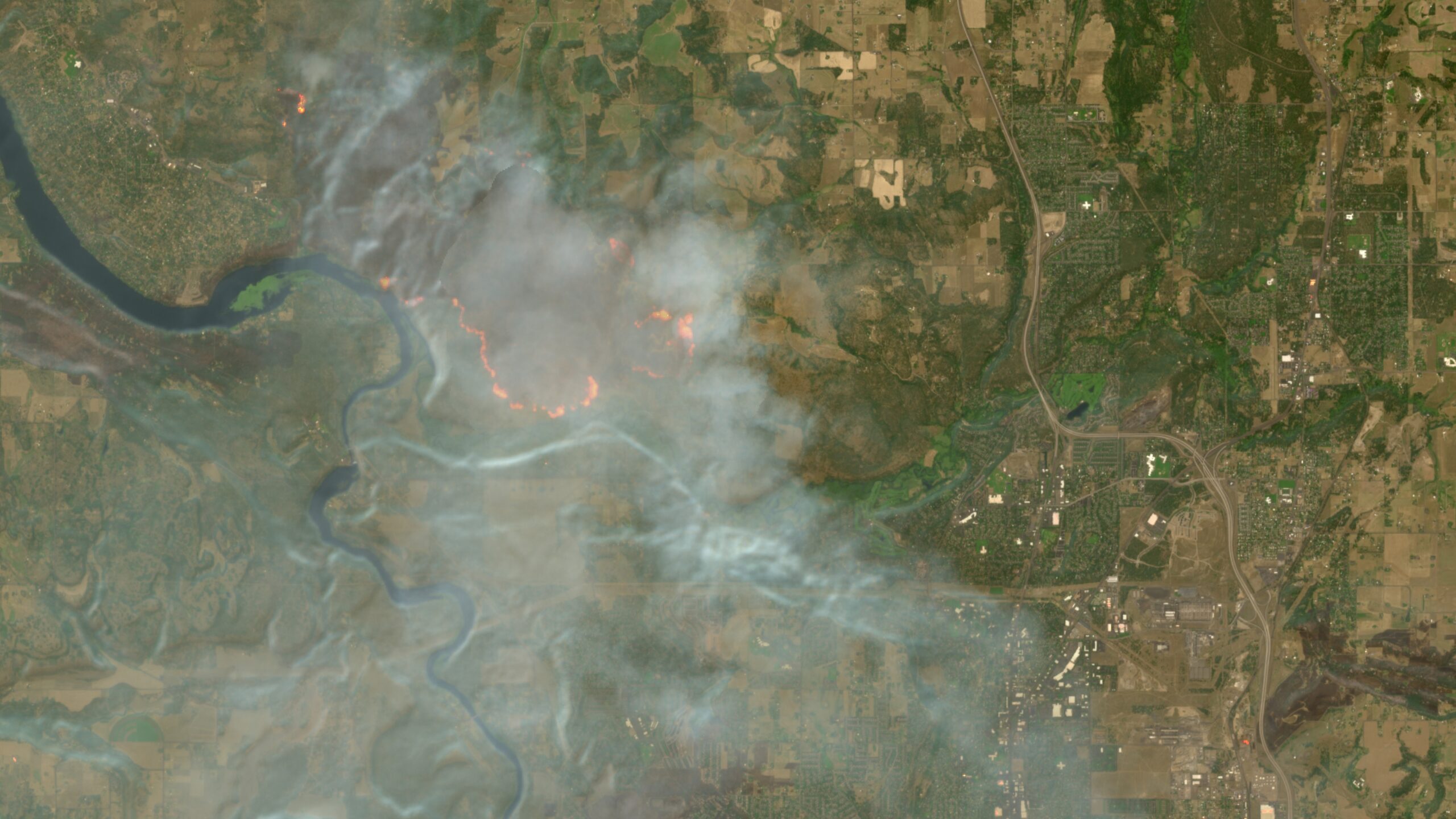
  • Active fires appear white or yellow, burning vegetation in red, and burned landscapes in dark brown or black.
  • The visualization is based on a script combining visible light, near-infrared, and short-wave infrared bands.
  • This tool provides a free and open resource for monitoring wildfires globally.

Europe's Copernicus Browser has enhanced its wildfire tracking capabilities with a new visualization layer, making it easier for the public to monitor active fires. The update, which went live on August 4, utilizes high-resolution imagery from the European Space Agency's Sentinel-2 satellites. This new layer, developed from a script by remote sensing expert Pierre Markuse and integrated with the advocacy of ESA's Simon Proud, displays active fires in white or yellow, burning vegetation in red, and burned landscapes in dark brown or black. The Sentinel-2 satellites offer multi-spectral imaging with resolutions as fine as 10 meters, providing significantly more detail than NASA's FIRMS tool, which has a coarser resolution of 250 meters. While Sentinel-2 imagery is updated every few days, its higher resolution makes it a valuable free resource for monitoring wildfires and other global events. The enhancement comes amid a period of record-breaking wildfire seasons worldwide, exacerbated by climate change, affecting regions such as Washington, Oregon, Canada, France, and Spain.

Frequently asked questions

The Copernicus Browser is Europe's free and open satellite imagery service, providing access to data from the European Space Agency's Sentinel satellites for Earth observation.

It combines visible light, near-infrared, and short-wave infrared bands from Sentinel-2 imagery to highlight active fires, burning vegetation, and burned landscapes with distinct colors.

The Sentinel-2 satellites provide multi-spectral imaging at resolutions as granular as 10 meters in certain bands.

While NASA's FIRMS tool offers faster updates, Sentinel-2 imagery through Copernicus Browser provides significantly higher resolution data, albeit with less frequent updates.

What Happens Next

01Users can now access the wildfire visualization layer directly within the Copernicus Browser.
02Further enhancements to satellite monitoring tools may be developed.

Get the newsletter.

Pick the topics you actually care about. We'll email when there's news worth your time, on the cadence you choose. Cancel any time from your account.

Cadence

How It Developed

Copernicus Browser added a wildfire visualization layer for Sentinel-2 imagery.
The new layer highlights active fires, burning vegetation, and burned landscapes.
This enhancement is based on a JavaScript script by remote sensing expert Pierre Markuse.
Simon Proud of the European Space Agency advocated for the script's integration.
The update aims to make tracking wildfires easier for the public.

Sources

T1
Europe’s free satellite service just made it easier to track wildfiresvar abtest_2166686 = new ABTest(2166686, 'impression');Ars Technica

Related Stories

Concorde prototype flew at supersonic speed to chase solar eclipse
7 Aug · 7:11 PM
World's largest solar telescope captures never-before-seen solar vortexes
7 Aug · 1:26 PM
New Quake Mission Pack Adds Maps and Mechanics
7 Aug · 6:06 PM
Cloudflare launches Kitesurf, a browser built for AI agents
7 Aug · 4:46 PM
Remembering the pre-Google web, when search was an experiment
7 Aug · 11:06 AM